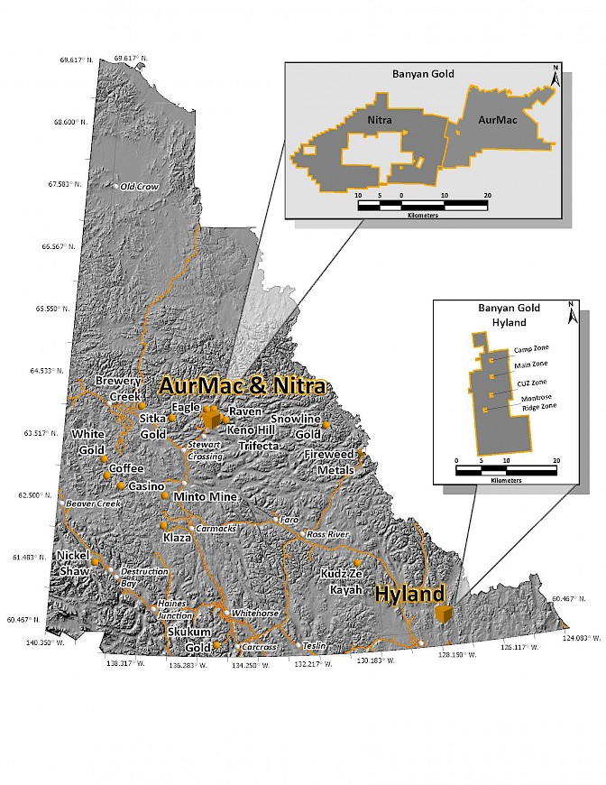
The AurMac Gold Project (formerly the Aurex-McQuesten Gold Project) (the “Project” or the “Property”) is located in the Mayo Mining district, approximately 40 kilometres northeast from the village of Mayo and 356 kilometres north of Whitehorse, within the traditional territory of the First Nation of Na-Cho Nyak Dun (NND). The Aurex claim block was acquired from Victoria Gold Corp. and the McQuesten claim block Project was acquired from Hecla Mining Company and is subject to royalties. (Refer to Press Releases of the Company dated September 18, 2025).
The AurMac Project has a National Instrument 43-101 Technical Report (NI-43-101) Indicated Mineral Resource of 2.274 million (“M”) ounces (“oz”) of gold (“Au”) (112.5 M tonnes at 0.63 g/t) and an Inferred Mineral Resource of 5.453 M oz of Au (280.6 M tonnes at 0.60 g/t ). This resource is located in two zones, the Airstrip and Powerline zones, is open in all directions and at depth, and has the potential for further expansion.
The Project covers 291 square kilometres and is easily road accessible with the all-weather Silver Trail Highway that transects the mineral claims as well as a network of four-wheel drive roads and trails that accesses the Project. Additionally, a three-phase power grid line exists on the Project.
The Project has a rich history of exploration and mining dating back to the beginning of the 1900s. Historically, there has been intense silver exploration, development, and mining for over 100 years at the nearby Keno and Galena Hill. The earliest prospecting activity for gold began as early as 1898, shortly after the Klondike gold rush.
The Project lies in the northern of the Selwyn Basin, and it is underlain by the meta-sedimentary rocks of Devono-Mississippian Earn Group and by the metaclastic rocks of the Late Proterozoic Yusezyu Formation of the Hyland Group, respectively. In the McQuesten area, local narrow granitic dykes commonly intrude the metaclastic rocks and are of probable Cretaceous age, related to the Tombstone Intrusive Suite. Gold mineralization is associated with gold bearing skarns and intrusive granitoid dykes. Regionally, the Tombstone Plutonic suite rocks are spatially and genetically associated with a range of precious and base-metal occurrences including the intrusion-related Eagle Gold Project of Victoria Gold at Dublin Gulch. Since acquiring the Project in early 2016, the Company has identified new target areas to the East based on anomalous gold soil geochemistry and several, significant gold-bearing skarn horizons that have not been previously drill-tested.
Table 1: Pit-Constrained Inferred and Indicated Mineral Resources – AurMac Project(1)(2)(3)(4)(5)
Notes to Table 1:
|
||||||||||||||||||||||||||||||||||||||||||||
The 100% owned, subject to certain royalties, Hyland Gold Project (the “Project” or the “Property”) is located in the Watson Lake Mining District in southeast Yukon, approximately 74 kilometres northeast from the town of Watson Lake within the traditional territory of the Liard First Nation, part of the Kaska Nations. The Project consists of 927 active Yukon registered quartz mineral claims totalling over 18,620 hectares in area that is currently accessible by vehicles on a winter road from Watson Lake.
Mineral exploration on the Project area began in the 1800s, with the discovery of the McMillan zinc-lead-silver deposit, 5 kilometres west of, and immediately contiguous to the Property. Exploration for gold mineralization was initiated in the region in 1981 by Archer Cathro on behalf of Kidd Creek Mines Ltd. and lead to the discovery of a 450 metre long, anomalous gold-arsenic-bismuth soil geochemical anomaly, known as the Main Zone. The Main Zone gold-silver deposit and additional gold showings such as the Camp Zone and Cuz Zone were the subject of intermittent exploration from the 1980s into the 2000s. In 2013, prospecting led to the discovery of the Montrose Ridge Zone, the southern extension of the Cuz Zone.
The Project is interpreted as a distal intrusion - related, sediment-hosted, structurally controlled, gold mineralized target. Gold mineralization is hosted within a Precambrian, interbedded phyllite and quartzite sequence of the Selwyn Basin that hosts numerous other gold occurrences elsewhere in the Yukon. Known zones of gold mineralization at the Property consist of the Main Zone, Camp Zone, Cuz Zone, and Montrose Ridge Zone forming a gold mineralized structural trend over 11 kilometres. Mineralization is controlled by a regional-scale, North trending structural trend known as the Quartz Lake Corridor that persist through and beyond the currently defined zones; therefore, the Property remains open to exploration both to the north and south.